|
|
|||||||||||||||||
| Point ID: 7924 | Downloads | Plots | Site Data | Code: 3509 |
|
|
|||||||||||||||||
| Download | |
|---|---|
| Site Descriptor Information | Site Time Series Data |
| Link to all available data | |
| View: | Time Series | All |
| Units: | m3/s |
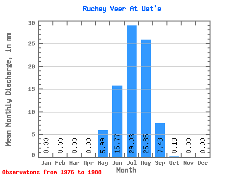
| Statistic | Jan | Feb | Mar | Apr | May | Jun | Jul | Aug | Sep | Oct | Nov | Dec | Annual |
|---|---|---|---|---|---|---|---|---|---|---|---|---|---|
| Mean | 0.00 | 0.00 | 0.00 | 0.00 | 5.94 | 15.73 | 29.11 | 25.91 | 7.45 | 0.10 | 0.00 | 0.00 | 86.16 |
| Standard Deviation | 0.00 | 0.00 | 0.00 | 0.00 | 19.15 | 17.40 | 24.77 | 23.33 | 5.57 | 0.34 | 0.00 | 0.00 | 68.80 |
| Min | 0.00 | 0.00 | 0.00 | 0.00 | 0.00 | 0.91 | 3.75 | 0.19 | 0.00 | 0.00 | 0.00 | 0.00 | 19.50 |
| Max | 0.00 | 0.00 | 0.00 | 0.00 | 63.67 | 59.81 | 65.55 | 76.78 | 17.95 | 1.12 | 0.00 | 0.00 | 238.54 |
| Coefficient of Variation | 3.22 | 1.11 | 0.85 | 0.90 | 0.75 | 3.32 | 0.80 |
 Return to R-Arctic Net Home Page