|
|
|||||||||||||||||
| Point ID: 7915 | Downloads | Plots | Site Data | Code: 3455 |
|
|
|||||||||||||||||
| Download | |
|---|---|
| Site Descriptor Information | Site Time Series Data |
| Link to all available data | |
| View: | Time Series | All |
| Units: | m3/s |
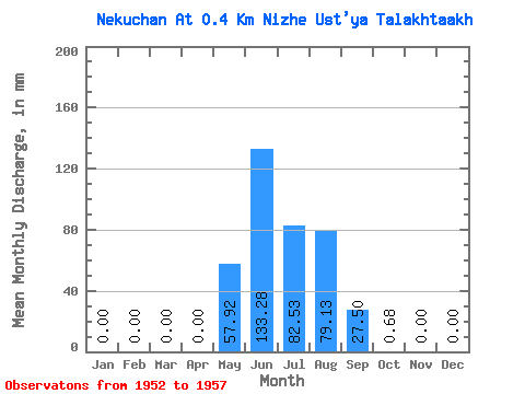
| Statistic | Jan | Feb | Mar | Apr | May | Jun | Jul | Aug | Sep | Oct | Nov | Dec | Annual |
|---|---|---|---|---|---|---|---|---|---|---|---|---|---|
| Mean | 0.00 | 0.00 | 0.00 | 0.00 | 57.89 | 133.33 | 82.47 | 79.12 | 27.55 | 0.73 | 0.00 | 0.00 | 363.37 |
| Standard Deviation | 0.00 | 0.00 | 0.00 | 0.00 | 66.05 | 67.34 | 32.89 | 31.90 | 26.78 | 0.31 | 0.00 | 0.00 | 85.94 |
| Min | 0.00 | 0.00 | 0.00 | 0.00 | 0.00 | 55.26 | 21.75 | 46.22 | 4.34 | 0.41 | 0.00 | 0.00 | 275.95 |
| Max | 0.00 | 0.00 | 0.00 | 0.00 | 154.97 | 244.73 | 108.75 | 118.27 | 72.36 | 1.22 | 0.00 | 0.00 | 505.17 |
| Coefficient of Variation | 1.14 | 0.51 | 0.40 | 0.40 | 0.97 | 0.43 | 0.24 |
 Return to R-Arctic Net Home Page