|
|
|||||||||||||||||
| Point ID: 7910 | Downloads | Plots | Site Data | Code: 3433 |
|
|
|||||||||||||||||
| Download | |
|---|---|
| Site Descriptor Information | Site Time Series Data |
| Link to all available data | |
| View: | Time Series | All |
| Units: | m3/s |
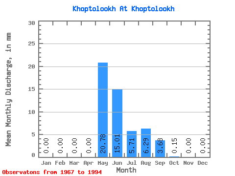
| Statistic | Jan | Feb | Mar | Apr | May | Jun | Jul | Aug | Sep | Oct | Nov | Dec | Annual |
|---|---|---|---|---|---|---|---|---|---|---|---|---|---|
| Mean | 0.00 | 0.00 | 0.00 | 0.00 | 20.74 | 15.07 | 5.66 | 6.23 | 3.71 | 0.13 | 0.00 | 0.00 | 46.31 |
| Standard Deviation | 0.00 | 0.00 | 0.00 | 0.00 | 20.03 | 19.55 | 10.48 | 11.26 | 5.10 | 0.32 | 0.00 | 0.00 | 49.90 |
| Min | 0.00 | 0.00 | 0.00 | 0.00 | 0.00 | 0.00 | 0.00 | -8.05 | -2.69 | 0.00 | 0.00 | 0.00 | 3.74 |
| Max | 0.00 | 0.00 | 0.00 | 0.00 | 70.24 | 59.49 | 51.22 | 38.05 | 17.00 | 1.46 | 0.00 | 0.00 | 203.07 |
| Coefficient of Variation | 0.97 | 1.30 | 1.85 | 1.81 | 1.38 | 2.36 | 1.08 |
 Return to R-Arctic Net Home Page