|
|
|||||||||||||||||
| Point ID: 7903 | Downloads | Plots | Site Data | Code: 3409 |
|
|
|||||||||||||||||
| Download | |
|---|---|
| Site Descriptor Information | Site Time Series Data |
| Link to all available data | |
| View: | Time Series | All |
| Units: | m3/s |
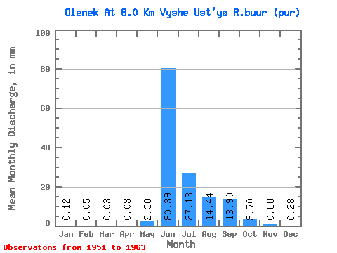
| Statistic | Jan | Feb | Mar | Apr | May | Jun | Jul | Aug | Sep | Oct | Nov | Dec | Annual |
|---|---|---|---|---|---|---|---|---|---|---|---|---|---|
| Mean | 0.12 | 0.05 | 0.03 | 0.03 | 2.38 | 80.39 | 27.12 | 14.44 | 13.90 | 3.70 | 0.88 | 0.28 | 139.93 |
| Standard Deviation | 0.07 | 0.04 | 0.03 | 0.02 | 5.87 | 20.92 | 16.38 | 9.28 | 8.04 | 2.05 | 0.42 | 0.16 | 31.79 |
| Min | 0.03 | 0.01 | 0.00 | 0.00 | 0.00 | 40.24 | 6.82 | 1.15 | 2.31 | 0.54 | 0.21 | 0.05 | 96.04 |
| Max | 0.23 | 0.14 | 0.08 | 0.05 | 19.23 | 110.98 | 53.12 | 29.59 | 25.63 | 8.15 | 1.66 | 0.55 | 191.79 |
| Coefficient of Variation | 0.60 | 0.72 | 0.78 | 0.69 | 2.46 | 0.26 | 0.60 | 0.64 | 0.58 | 0.55 | 0.48 | 0.58 | 0.23 |
 Return to R-Arctic Net Home Page