|
|
|||||||||||||||||
| Point ID: 7899 | Downloads | Plots | Site Data | Code: 3393 |
|
|
|||||||||||||||||
| Download | |
|---|---|
| Site Descriptor Information | Site Time Series Data |
| Link to all available data | |
| View: | Time Series | All |
| Units: | m3/s |
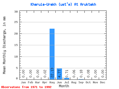
| Statistic | Jan | Feb | Mar | Apr | May | Jun | Jul | Aug | Sep | Oct | Nov | Dec | Annual |
|---|---|---|---|---|---|---|---|---|---|---|---|---|---|
| Mean | 0.00 | 0.00 | 0.00 | 0.02 | 22.13 | 4.77 | 0.70 | 0.06 | 0.18 | 0.08 | 0.00 | 0.00 | 21.89 |
| Standard Deviation | 0.00 | 0.00 | 0.00 | 0.03 | 20.25 | 4.53 | 1.34 | 0.17 | 0.65 | 0.30 | 0.00 | 0.00 | 21.92 |
| Min | 0.00 | 0.00 | 0.00 | 0.00 | 0.24 | 0.01 | 0.00 | 0.00 | 0.00 | 0.00 | 0.00 | 0.00 | 0.24 |
| Max | 0.00 | 0.00 | 0.00 | 0.08 | 60.06 | 15.07 | 5.00 | 0.64 | 2.35 | 1.14 | 0.00 | 0.00 | 65.14 |
| Coefficient of Variation | 1.77 | 0.92 | 0.95 | 1.91 | 2.69 | 3.57 | 3.74 | 1.00 |
 Return to R-Arctic Net Home Page