|
|
|||||||||||||||||
| Point ID: 7881 | Downloads | Plots | Site Data | Code: 3358 |
|
|
|||||||||||||||||
| Download | |
|---|---|
| Site Descriptor Information | Site Time Series Data |
| Link to all available data | |
| View: | Time Series | All |
| Units: | m3/s |
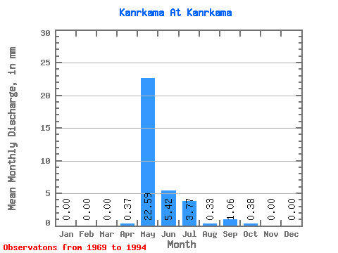
| Statistic | Jan | Feb | Mar | Apr | May | Jun | Jul | Aug | Sep | Oct | Nov | Dec | Annual |
|---|---|---|---|---|---|---|---|---|---|---|---|---|---|
| Mean | 0.00 | 0.00 | 0.00 | 0.37 | 22.59 | 5.42 | 3.77 | 0.34 | 1.06 | 0.38 | 0.00 | 0.00 | 29.27 |
| Standard Deviation | 0.00 | 0.00 | 0.00 | 0.90 | 15.63 | 4.98 | 8.75 | 1.03 | 1.72 | 0.78 | 0.00 | 0.00 | 16.48 |
| Min | 0.00 | 0.00 | 0.00 | 0.00 | 0.84 | 0.00 | 0.00 | 0.00 | 0.00 | 0.00 | 0.00 | 0.00 | 4.71 |
| Max | 0.00 | 0.00 | 0.00 | 3.70 | 64.85 | 19.62 | 30.22 | 4.59 | 5.55 | 3.25 | 0.00 | 0.00 | 64.55 |
| Coefficient of Variation | 2.43 | 0.69 | 0.92 | 2.32 | 3.07 | 1.62 | 2.04 | 0.56 |
 Return to R-Arctic Net Home Page