|
|
|||||||||||||||||
| Point ID: 787 | Downloads | Plots | Site Data | Code: 07HF001 |
|
|
|||||||||||||||||
| Download | |
|---|---|
| Site Descriptor Information | Site Time Series Data |
| Link to all available data | |
| View: | Time Series | All |
| Units: | m3/s |
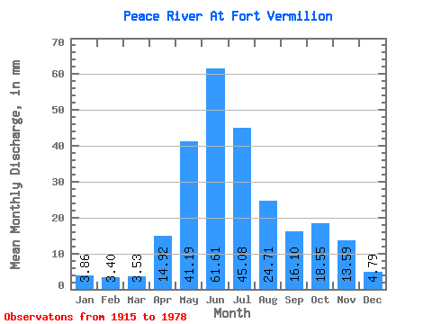
| Statistic | Jan | Feb | Mar | Apr | May | Jun | Jul | Aug | Sep | Oct | Nov | Dec | Annual |
|---|---|---|---|---|---|---|---|---|---|---|---|---|---|
| Mean | 3.86 | 3.43 | 3.53 | 14.92 | 41.18 | 61.61 | 45.07 | 24.70 | 16.10 | 18.55 | 13.59 | 4.79 | 327.13 |
| Standard Deviation | 0.34 | 0.74 | 0.55 | 4.92 | 11.98 | 25.33 | 20.51 | 12.94 | 4.75 | 5.20 | 2.39 | 0.96 | 37.29 |
| Min | 3.41 | 2.48 | 2.95 | 8.29 | 22.70 | 21.15 | 15.37 | 11.26 | 7.61 | 7.51 | 10.08 | 3.45 | 304.51 |
| Max | 4.33 | 4.61 | 4.49 | 19.30 | 63.65 | 112.75 | 81.78 | 62.93 | 26.50 | 26.54 | 16.50 | 5.96 | 370.17 |
| Coefficient of Variation | 0.09 | 0.22 | 0.16 | 0.33 | 0.29 | 0.41 | 0.46 | 0.52 | 0.29 | 0.28 | 0.18 | 0.20 | 0.11 |
 Return to R-Arctic Net Home Page