|
|
|||||||||||||||||
| Point ID: 7864 | Downloads | Plots | Site Data | Code: 3304 |
|
|
|||||||||||||||||
| Download | |
|---|---|
| Site Descriptor Information | Site Time Series Data |
| Link to all available data | |
| View: | Time Series | All |
| Units: | m3/s |
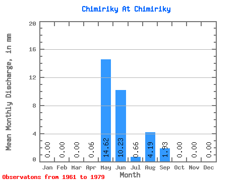
| Statistic | Jan | Feb | Mar | Apr | May | Jun | Jul | Aug | Sep | Oct | Nov | Dec | Annual |
|---|---|---|---|---|---|---|---|---|---|---|---|---|---|
| Mean | 0.00 | 0.00 | 0.00 | 0.07 | 14.59 | 10.22 | 0.69 | 4.19 | 1.93 | 0.01 | 0.00 | 0.00 | 31.52 |
| Standard Deviation | 0.00 | 0.00 | 0.00 | 0.30 | 24.47 | 12.29 | 1.77 | 12.71 | 5.85 | 0.03 | 0.00 | 0.00 | 37.36 |
| Min | 0.00 | 0.00 | 0.00 | 0.00 | 0.00 | 0.00 | 0.00 | 0.00 | 0.00 | 0.00 | 0.00 | 0.00 | 0.00 |
| Max | 0.00 | 0.00 | 0.00 | 1.29 | 95.03 | 44.38 | 6.64 | 53.16 | 23.80 | 0.13 | 0.00 | 0.00 | 119.75 |
| Coefficient of Variation | 4.24 | 1.68 | 1.20 | 2.57 | 3.04 | 3.03 | 4.24 | 1.19 |
 Return to R-Arctic Net Home Page