|
|
|||||||||||||||||
| Point ID: 7853 | Downloads | Plots | Site Data | Code: 3265 |
|
|
|||||||||||||||||
| Download | |
|---|---|
| Site Descriptor Information | Site Time Series Data |
| Link to all available data | |
| View: | Time Series | All |
| Units: | m3/s |
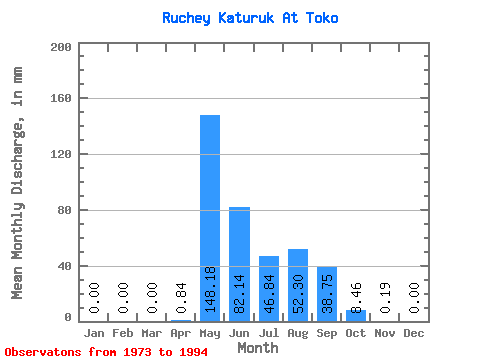
| Statistic | Jan | Feb | Mar | Apr | May | Jun | Jul | Aug | Sep | Oct | Nov | Dec | Annual |
|---|---|---|---|---|---|---|---|---|---|---|---|---|---|
| Mean | 0.00 | 0.00 | 0.00 | 0.84 | 148.14 | 82.14 | 46.86 | 52.29 | 38.75 | 8.44 | 0.22 | 0.00 | 403.87 |
| Standard Deviation | 0.00 | 0.00 | 0.00 | 2.60 | 67.47 | 102.31 | 42.15 | 37.72 | 23.93 | 6.01 | 0.51 | 0.00 | 130.43 |
| Min | 0.00 | 0.00 | 0.00 | 0.00 | 56.62 | 21.28 | 3.93 | 7.99 | 10.32 | 0.20 | 0.00 | 0.00 | 253.25 |
| Max | 0.00 | 0.00 | 0.00 | 9.67 | 397.04 | 494.54 | 145.89 | 147.22 | 81.24 | 19.98 | 2.00 | 0.00 | 746.48 |
| Coefficient of Variation | 3.08 | 0.46 | 1.25 | 0.90 | 0.72 | 0.62 | 0.71 | 2.33 | 0.32 |
 Return to R-Arctic Net Home Page