|
|
|||||||||||||||||
| Point ID: 785 | Downloads | Plots | Site Data | Code: 07HC907 |
|
|
|||||||||||||||||
| Download | |
|---|---|
| Site Descriptor Information | Site Time Series Data |
| Link to all available data | |
| View: | Time Series | All |
| Units: | m3/s |
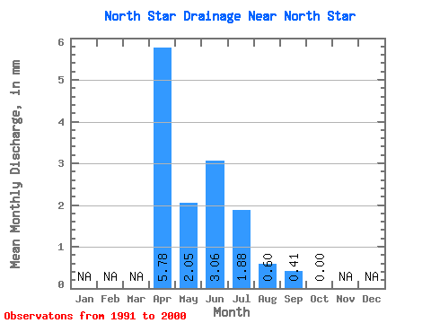
| Statistic | Jan | Feb | Mar | Apr | May | Jun | Jul | Aug | Sep | Oct | Nov | Dec | Annual |
|---|---|---|---|---|---|---|---|---|---|---|---|---|---|
| Mean | 5.82 | 2.06 | 3.06 | 1.84 | 0.62 | 0.38 | 0.00 | ||||||
| Standard Deviation | 4.75 | 3.83 | 6.29 | 3.80 | 1.91 | 1.17 | 0.00 | ||||||
| Min | 0.00 | 0.00 | 0.00 | 0.00 | 0.00 | 0.00 | 0.00 | ||||||
| Max | 12.47 | 12.12 | 20.15 | 10.84 | 6.06 | 3.72 | 0.00 | ||||||
| Coefficient of Variation | 0.82 | 1.85 | 2.06 | 2.06 | 3.07 | 3.09 |
 Return to R-Arctic Net Home Page