|
|
|||||||||||||||||
| Point ID: 7847 | Downloads | Plots | Site Data | Code: 3258 |
|
|
|||||||||||||||||
| Download | |
|---|---|
| Site Descriptor Information | Site Time Series Data |
| Link to all available data | |
| View: | Time Series | All |
| Units: | m3/s |
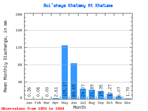
| Statistic | Jan | Feb | Mar | Apr | May | Jun | Jul | Aug | Sep | Oct | Nov | Dec | Annual |
|---|---|---|---|---|---|---|---|---|---|---|---|---|---|
| Mean | 0.35 | 0.06 | 0.00 | 2.62 | 125.15 | 83.69 | 24.06 | 21.88 | 19.35 | 12.26 | 6.06 | 1.71 | 302.79 |
| Standard Deviation | 1.16 | 0.34 | 0.00 | 7.14 | 64.09 | 59.09 | 17.36 | 15.70 | 9.20 | 6.73 | 4.86 | 3.00 | 97.80 |
| Min | 0.00 | 0.00 | 0.00 | 0.00 | 31.25 | 11.29 | 5.10 | 4.30 | 4.17 | 2.38 | 0.18 | 0.00 | 178.15 |
| Max | 6.06 | 1.96 | 0.01 | 38.47 | 355.56 | 223.03 | 91.72 | 60.58 | 43.02 | 29.33 | 17.81 | 10.42 | 598.85 |
| Coefficient of Variation | 3.28 | 5.83 | 5.83 | 2.73 | 0.51 | 0.71 | 0.72 | 0.72 | 0.47 | 0.55 | 0.80 | 1.75 | 0.32 |
 Return to R-Arctic Net Home Page