|
|
|||||||||||||||||
| Point ID: 7843 | Downloads | Plots | Site Data | Code: 3251 |
|
|
|||||||||||||||||
| Download | |
|---|---|
| Site Descriptor Information | Site Time Series Data |
| Link to all available data | |
| View: | Time Series | All |
| Units: | m3/s |
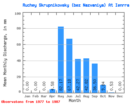
| Statistic | Jan | Feb | Mar | Apr | May | Jun | Jul | Aug | Sep | Oct | Nov | Dec | Annual |
|---|---|---|---|---|---|---|---|---|---|---|---|---|---|
| Mean | 0.00 | 0.00 | 0.00 | 4.58 | 82.14 | 67.16 | 42.23 | 42.81 | 36.55 | 9.87 | 0.45 | 0.00 | 290.27 |
| Standard Deviation | 0.00 | 0.00 | 0.00 | 10.91 | 47.28 | 35.38 | 20.25 | 28.29 | 23.71 | 8.04 | 0.74 | 0.00 | 91.50 |
| Min | 0.00 | 0.00 | 0.00 | 0.00 | 36.44 | 15.87 | 18.22 | 12.02 | 6.52 | 1.46 | 0.00 | 0.00 | 164.78 |
| Max | 0.00 | 0.00 | 0.00 | 35.27 | 193.11 | 134.01 | 92.91 | 87.44 | 65.24 | 25.50 | 2.29 | 0.00 | 425.63 |
| Coefficient of Variation | 2.38 | 0.58 | 0.53 | 0.48 | 0.66 | 0.65 | 0.81 | 1.64 | 0.32 |
 Return to R-Arctic Net Home Page