|
|
|||||||||||||||||
| Point ID: 7835 | Downloads | Plots | Site Data | Code: 3214 |
|
|
|||||||||||||||||
| Download | |
|---|---|
| Site Descriptor Information | Site Time Series Data |
| Link to all available data | |
| View: | Time Series | All |
| Units: | m3/s |
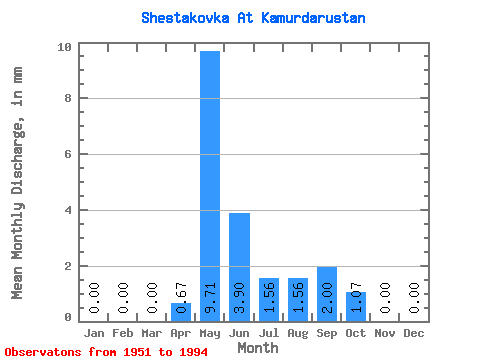
| Statistic | Jan | Feb | Mar | Apr | May | Jun | Jul | Aug | Sep | Oct | Nov | Dec | Annual |
|---|---|---|---|---|---|---|---|---|---|---|---|---|---|
| Mean | 0.00 | 0.00 | 0.00 | 0.67 | 9.70 | 3.90 | 1.56 | 1.56 | 2.00 | 1.07 | 0.01 | 0.00 | 20.70 |
| Standard Deviation | 0.00 | 0.00 | 0.00 | 1.51 | 7.91 | 9.91 | 1.99 | 1.59 | 1.57 | 1.62 | 0.02 | 0.00 | 17.39 |
| Min | 0.00 | 0.00 | 0.00 | 0.00 | 0.25 | 0.30 | 0.02 | 0.02 | 0.14 | 0.02 | 0.00 | 0.00 | 2.07 |
| Max | 0.00 | 0.00 | 0.00 | 7.78 | 29.93 | 66.33 | 8.03 | 6.77 | 6.86 | 8.98 | 0.14 | 0.00 | 100.80 |
| Coefficient of Variation | 2.27 | 0.81 | 2.54 | 1.28 | 1.02 | 0.78 | 1.51 | 3.58 | 0.84 |
 Return to R-Arctic Net Home Page