|
|
|||||||||||||||||
| Point ID: 7833 | Downloads | Plots | Site Data | Code: 3205 |
|
|
|||||||||||||||||
| Download | |
|---|---|
| Site Descriptor Information | Site Time Series Data |
| Link to all available data | |
| View: | Time Series | All |
| Units: | m3/s |
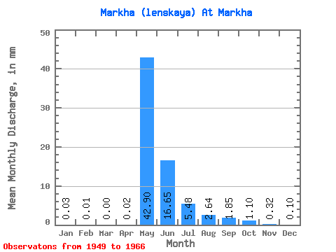
| Statistic | Jan | Feb | Mar | Apr | May | Jun | Jul | Aug | Sep | Oct | Nov | Dec | Annual |
|---|---|---|---|---|---|---|---|---|---|---|---|---|---|
| Mean | 0.03 | 0.01 | 0.00 | 0.02 | 42.90 | 16.65 | 5.47 | 2.64 | 1.85 | 1.10 | 0.32 | 0.10 | 70.41 |
| Standard Deviation | 0.07 | 0.02 | 0.00 | 0.04 | 23.38 | 11.13 | 6.54 | 3.40 | 1.58 | 0.89 | 0.36 | 0.17 | 33.67 |
| Min | 0.00 | 0.00 | 0.00 | 0.00 | 6.33 | 4.09 | 0.84 | 0.56 | 0.34 | 0.19 | 0.00 | 0.00 | 18.35 |
| Max | 0.26 | 0.10 | 0.00 | 0.14 | 103.05 | 46.79 | 28.56 | 12.69 | 5.48 | 3.34 | 1.24 | 0.59 | 156.15 |
| Coefficient of Variation | 2.42 | 4.24 | 4.24 | 2.28 | 0.55 | 0.67 | 1.20 | 1.29 | 0.85 | 0.81 | 1.14 | 1.77 | 0.48 |
 Return to R-Arctic Net Home Page