|
|
|||||||||||||||||
| Point ID: 7832 | Downloads | Plots | Site Data | Code: 3203 |
|
|
|||||||||||||||||
| Download | |
|---|---|
| Site Descriptor Information | Site Time Series Data |
| Link to all available data | |
| View: | Time Series | All |
| Units: | m3/s |
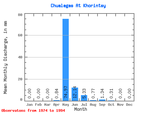
| Statistic | Jan | Feb | Mar | Apr | May | Jun | Jul | Aug | Sep | Oct | Nov | Dec | Annual |
|---|---|---|---|---|---|---|---|---|---|---|---|---|---|
| Mean | 0.00 | 0.00 | 0.00 | 0.85 | 74.97 | 12.16 | 5.31 | 0.78 | 1.32 | 0.30 | 0.00 | 0.00 | 100.71 |
| Standard Deviation | 0.00 | 0.00 | 0.00 | 1.44 | 37.42 | 13.89 | 10.48 | 1.32 | 2.37 | 0.79 | 0.00 | 0.00 | 53.94 |
| Min | 0.00 | 0.00 | 0.00 | 0.00 | 18.43 | 0.20 | 0.00 | 0.00 | 0.00 | 0.00 | 0.00 | 0.00 | 23.03 |
| Max | 0.00 | 0.00 | 0.00 | 4.71 | 132.11 | 42.13 | 43.52 | 3.53 | 9.42 | 3.17 | 0.00 | 0.00 | 184.85 |
| Coefficient of Variation | 1.70 | 0.50 | 1.14 | 1.98 | 1.68 | 1.80 | 2.66 | 0.54 |
 Return to R-Arctic Net Home Page