|
|
|||||||||||||||||
| Point ID: 7826 | Downloads | Plots | Site Data | Code: 3191 |
|
|
|||||||||||||||||
| Download | |
|---|---|
| Site Descriptor Information | Site Time Series Data |
| Link to all available data | |
| View: | Time Series | All |
| Units: | m3/s |
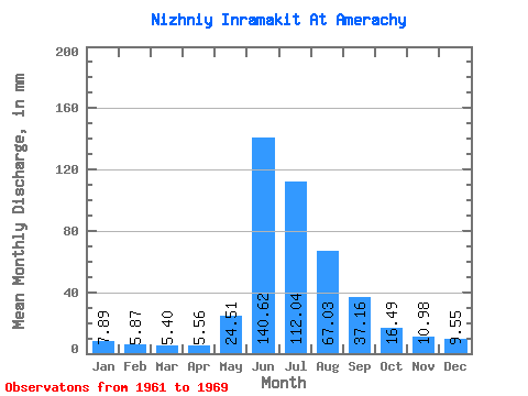
| Statistic | Jan | Feb | Mar | Apr | May | Jun | Jul | Aug | Sep | Oct | Nov | Dec | Annual |
|---|---|---|---|---|---|---|---|---|---|---|---|---|---|
| Mean | 7.89 | 5.92 | 5.40 | 5.55 | 24.51 | 140.62 | 112.03 | 67.02 | 37.16 | 16.49 | 10.98 | 9.54 | 441.76 |
| Standard Deviation | 0.61 | 0.63 | 0.53 | 0.83 | 13.17 | 41.09 | 24.66 | 34.06 | 13.28 | 2.59 | 0.78 | 0.94 | 78.87 |
| Min | 6.99 | 5.16 | 4.68 | 4.24 | 8.86 | 60.03 | 80.73 | 27.32 | 21.68 | 14.13 | 9.72 | 7.68 | 359.69 |
| Max | 8.96 | 6.82 | 6.30 | 6.62 | 51.20 | 191.06 | 144.73 | 139.31 | 64.32 | 21.32 | 12.24 | 10.54 | 602.24 |
| Coefficient of Variation | 0.08 | 0.11 | 0.10 | 0.15 | 0.54 | 0.29 | 0.22 | 0.51 | 0.36 | 0.16 | 0.07 | 0.10 | 0.18 |
 Return to R-Arctic Net Home Page