|
|
|||||||||||||||||
| Point ID: 7818 | Downloads | Plots | Site Data | Code: 3161 |
|
|
|||||||||||||||||
| Download | |
|---|---|
| Site Descriptor Information | Site Time Series Data |
| Link to all available data | |
| View: | Time Series | All |
| Units: | m3/s |
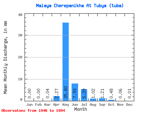
| Statistic | Jan | Feb | Mar | Apr | May | Jun | Jul | Aug | Sep | Oct | Nov | Dec | Annual |
|---|---|---|---|---|---|---|---|---|---|---|---|---|---|
| Mean | 0.00 | 0.00 | 0.04 | 2.27 | 35.79 | 7.93 | 5.38 | 1.02 | 1.21 | 0.48 | 0.06 | 0.01 | 53.59 |
| Standard Deviation | 0.00 | 0.00 | 0.26 | 5.07 | 23.79 | 7.38 | 17.71 | 1.89 | 1.93 | 0.53 | 0.14 | 0.02 | 37.82 |
| Min | 0.00 | 0.00 | 0.00 | 0.00 | 0.54 | 0.49 | 0.02 | 0.00 | 0.00 | 0.00 | 0.00 | 0.00 | 1.77 |
| Max | 0.00 | 0.00 | 1.66 | 22.82 | 91.36 | 31.06 | 113.63 | 10.51 | 9.23 | 1.77 | 0.72 | 0.11 | 218.09 |
| Coefficient of Variation | 6.40 | 2.23 | 0.67 | 0.93 | 3.29 | 1.84 | 1.59 | 1.10 | 2.36 | 4.32 | 0.71 |
 Return to R-Arctic Net Home Page