|
|
|||||||||||||||||
| Point ID: 7812 | Downloads | Plots | Site Data | Code: 3140 |
|
|
|||||||||||||||||
| Download | |
|---|---|
| Site Descriptor Information | Site Time Series Data |
| Link to all available data | |
| View: | Time Series | All |
| Units: | m3/s |
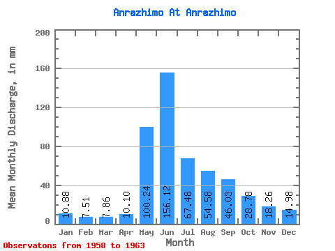
| Statistic | Jan | Feb | Mar | Apr | May | Jun | Jul | Aug | Sep | Oct | Nov | Dec | Annual |
|---|---|---|---|---|---|---|---|---|---|---|---|---|---|
| Mean | 10.87 | 7.58 | 7.86 | 10.10 | 100.22 | 156.12 | 67.47 | 54.58 | 46.03 | 28.77 | 18.26 | 14.98 | 515.80 |
| Standard Deviation | 2.23 | 1.66 | 1.63 | 1.05 | 13.67 | 45.30 | 20.63 | 12.26 | 11.68 | 6.63 | 5.55 | 2.86 | 111.34 |
| Min | 7.57 | 5.72 | 5.95 | 9.26 | 84.03 | 103.50 | 35.46 | 36.75 | 34.86 | 20.87 | 11.89 | 11.71 | 437.07 |
| Max | 12.50 | 9.59 | 10.55 | 12.17 | 117.83 | 218.09 | 95.11 | 70.55 | 68.64 | 38.78 | 21.99 | 17.03 | 594.52 |
| Coefficient of Variation | 0.20 | 0.22 | 0.21 | 0.10 | 0.14 | 0.29 | 0.31 | 0.23 | 0.25 | 0.23 | 0.30 | 0.19 | 0.22 |
 Return to R-Arctic Net Home Page