|
|
|||||||||||||||||
| Point ID: 7799 | Downloads | Plots | Site Data | Code: 3090 |
|
|
|||||||||||||||||
| Download | |
|---|---|
| Site Descriptor Information | Site Time Series Data |
| Link to all available data | |
| View: | Time Series | All |
| Units: | m3/s |
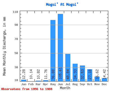
| Statistic | Jan | Feb | Mar | Apr | May | Jun | Jul | Aug | Sep | Oct | Nov | Dec | Annual |
|---|---|---|---|---|---|---|---|---|---|---|---|---|---|
| Mean | 12.28 | 10.23 | 10.82 | 11.76 | 96.87 | 105.61 | 48.83 | 34.92 | 32.53 | 27.18 | 16.62 | 14.42 | 420.96 |
| Standard Deviation | 2.44 | 2.32 | 2.79 | 3.41 | 18.44 | 42.23 | 17.98 | 12.22 | 10.45 | 8.16 | 4.13 | 3.69 | 75.50 |
| Min | 8.24 | 6.21 | 6.06 | 6.21 | 61.52 | 45.73 | 27.05 | 17.30 | 16.61 | 13.53 | 8.93 | 8.90 | 275.68 |
| Max | 17.03 | 15.02 | 18.68 | 20.60 | 129.09 | 199.38 | 106.71 | 68.80 | 50.91 | 44.22 | 26.32 | 25.13 | 612.41 |
| Coefficient of Variation | 0.20 | 0.23 | 0.26 | 0.29 | 0.19 | 0.40 | 0.37 | 0.35 | 0.32 | 0.30 | 0.25 | 0.26 | 0.18 |
 Return to R-Arctic Net Home Page