|
|
|||||||||||||||||
| Point ID: 7798 | Downloads | Plots | Site Data | Code: 3085 |
|
|
|||||||||||||||||
| Download | |
|---|---|
| Site Descriptor Information | Site Time Series Data |
| Link to all available data | |
| View: | Time Series | All |
| Units: | m3/s |
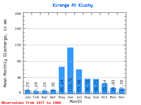
| Statistic | Jan | Feb | Mar | Apr | May | Jun | Jul | Aug | Sep | Oct | Nov | Dec | Annual |
|---|---|---|---|---|---|---|---|---|---|---|---|---|---|
| Mean | 9.29 | 7.15 | 7.24 | 9.95 | 66.13 | 113.72 | 59.97 | 36.73 | 36.21 | 25.14 | 14.83 | 12.39 | 401.76 |
| Standard Deviation | 2.04 | 1.64 | 1.27 | 2.59 | 11.46 | 26.66 | 37.88 | 15.70 | 14.51 | 5.80 | 3.57 | 3.70 | 88.99 |
| Min | 6.41 | 4.90 | 5.22 | 6.68 | 46.56 | 50.48 | 26.31 | 18.38 | 18.42 | 17.26 | 10.21 | 6.84 | 302.83 |
| Max | 12.50 | 9.52 | 9.42 | 14.81 | 85.19 | 141.79 | 160.49 | 75.86 | 60.96 | 36.39 | 20.77 | 17.73 | 595.19 |
| Coefficient of Variation | 0.22 | 0.23 | 0.17 | 0.26 | 0.17 | 0.23 | 0.63 | 0.43 | 0.40 | 0.23 | 0.24 | 0.30 | 0.22 |
 Return to R-Arctic Net Home Page