|
|
|||||||||||||||||
| Point ID: 7797 | Downloads | Plots | Site Data | Code: 3080 |
|
|
|||||||||||||||||
| Download | |
|---|---|
| Site Descriptor Information | Site Time Series Data |
| Link to all available data | |
| View: | Time Series | All |
| Units: | m3/s |
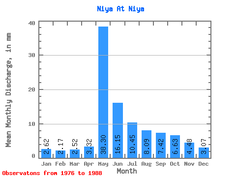
| Statistic | Jan | Feb | Mar | Apr | May | Jun | Jul | Aug | Sep | Oct | Nov | Dec | Annual |
|---|---|---|---|---|---|---|---|---|---|---|---|---|---|
| Mean | 2.62 | 2.19 | 2.52 | 3.32 | 38.29 | 16.15 | 10.45 | 8.09 | 7.42 | 6.63 | 4.49 | 3.07 | 110.61 |
| Standard Deviation | 2.22 | 2.18 | 2.19 | 1.90 | 10.51 | 7.37 | 8.41 | 5.76 | 5.31 | 4.26 | 3.27 | 1.91 | 40.85 |
| Min | 0.28 | 0.38 | 0.39 | 1.30 | 22.60 | 6.38 | 2.95 | 2.44 | 2.30 | 2.02 | 1.54 | 0.92 | 71.57 |
| Max | 8.62 | 8.42 | 8.65 | 7.45 | 57.74 | 31.10 | 31.63 | 22.76 | 21.71 | 18.41 | 13.51 | 7.31 | 212.32 |
| Coefficient of Variation | 0.85 | 1.00 | 0.87 | 0.57 | 0.28 | 0.46 | 0.81 | 0.71 | 0.71 | 0.64 | 0.73 | 0.62 | 0.37 |
 Return to R-Arctic Net Home Page