|
|
|||||||||||||||||
| Point ID: 7787 | Downloads | Plots | Site Data | Code: 3017 |
|
|
|||||||||||||||||
| Download | |
|---|---|
| Site Descriptor Information | Site Time Series Data |
| Link to all available data | |
| View: | Time Series | All |
| Units: | m3/s |
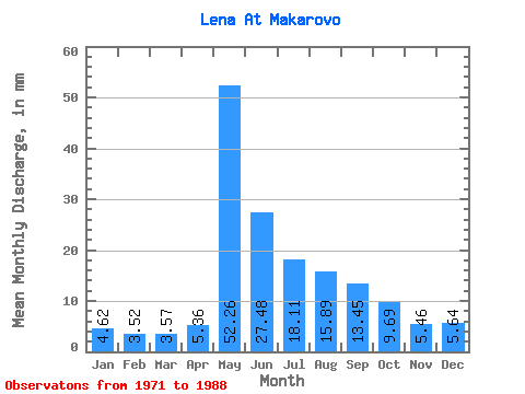
| Statistic | Jan | Feb | Mar | Apr | May | Jun | Jul | Aug | Sep | Oct | Nov | Dec | Annual |
|---|---|---|---|---|---|---|---|---|---|---|---|---|---|
| Mean | 4.62 | 3.55 | 3.57 | 5.36 | 52.25 | 27.48 | 18.11 | 15.89 | 13.45 | 9.69 | 5.46 | 5.64 | 164.15 |
| Standard Deviation | 1.30 | 1.01 | 1.01 | 3.57 | 11.57 | 8.88 | 8.22 | 7.15 | 4.89 | 3.60 | 1.62 | 1.62 | 33.97 |
| Min | 3.12 | 2.32 | 2.43 | 2.72 | 31.17 | 10.95 | 8.37 | 7.93 | 7.44 | 5.34 | 3.56 | 3.62 | 126.67 |
| Max | 8.19 | 6.52 | 6.44 | 19.05 | 68.88 | 45.12 | 36.22 | 30.88 | 24.00 | 19.30 | 8.88 | 9.62 | 247.93 |
| Coefficient of Variation | 0.28 | 0.28 | 0.28 | 0.67 | 0.22 | 0.32 | 0.45 | 0.45 | 0.36 | 0.37 | 0.30 | 0.29 | 0.21 |
 Return to R-Arctic Net Home Page