|
|
|||||||||||||||||
| Point ID: 7772 | Downloads | Plots | Site Data | Code: 10ED009 |
|
|
|||||||||||||||||
| Download | |
|---|---|
| Site Descriptor Information | Site Time Series Data |
| Link to all available data | |
| View: | Time Series | All |
| Units: | m3/s |
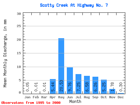
| Statistic | Jan | Feb | Mar | Apr | May | Jun | Jul | Aug | Sep | Oct | Nov | Dec | Annual |
|---|---|---|---|---|---|---|---|---|---|---|---|---|---|
| Mean | 0.05 | 0.01 | 0.01 | 5.44 | 20.52 | 9.77 | 7.25 | 6.58 | 6.27 | 5.26 | 1.78 | 0.31 | 62.86 |
| Standard Deviation | 0.05 | 0.01 | 0.01 | 4.87 | 8.81 | 7.67 | 6.65 | 8.25 | 6.61 | 3.13 | 1.70 | 0.28 | 31.39 |
| Min | 0.00 | 0.00 | 0.00 | 0.14 | 8.21 | 0.54 | 0.00 | 0.01 | 0.01 | 0.01 | 0.01 | 0.00 | 17.60 |
| Max | 0.13 | 0.01 | 0.01 | 13.47 | 30.89 | 20.79 | 15.51 | 23.07 | 15.65 | 9.65 | 4.77 | 0.64 | 103.14 |
| Coefficient of Variation | 1.08 | 0.78 | 1.09 | 0.90 | 0.43 | 0.79 | 0.92 | 1.25 | 1.05 | 0.59 | 0.95 | 0.90 | 0.50 |
 Return to R-Arctic Net Home Page