|
|
|||||||||||||||||
| Point ID: 7759 | Downloads | Plots | Site Data | Code: 05OF023 |
|
|
|||||||||||||||||
| Download | |
|---|---|
| Site Descriptor Information | Site Time Series Data |
| Link to all available data | |
| View: | Time Series | All |
| Units: | m3/s |
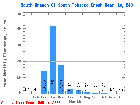
| Statistic | Jan | Feb | Mar | Apr | May | Jun | Jul | Aug | Sep | Oct | Nov | Dec | Annual |
|---|---|---|---|---|---|---|---|---|---|---|---|---|---|
| Mean | 13.64 | 41.69 | 17.42 | 3.06 | 2.54 | 0.76 | 0.61 | 0.34 | |||||
| Standard Deviation | 17.40 | 28.75 | 11.85 | 2.29 | 3.73 | 0.97 | 0.66 | 0.22 | |||||
| Min | 0.15 | 1.11 | 1.37 | 1.11 | 0.08 | 0.00 | 0.00 | 0.08 | |||||
| Max | 40.36 | 75.32 | 27.62 | 7.09 | 9.99 | 2.52 | 1.70 | 0.61 | |||||
| Coefficient of Variation | 1.27 | 0.69 | 0.68 | 0.75 | 1.47 | 1.28 | 1.07 | 0.64 |
 Return to R-Arctic Net Home Page