|
|
|||||||||||||||||
| Point ID: 774 | Downloads | Plots | Site Data | Code: 07GJ004 |
|
|
|||||||||||||||||
| Download | |
|---|---|
| Site Descriptor Information | Site Time Series Data |
| Link to all available data | |
| View: | Time Series | All |
| Units: | m3/s |
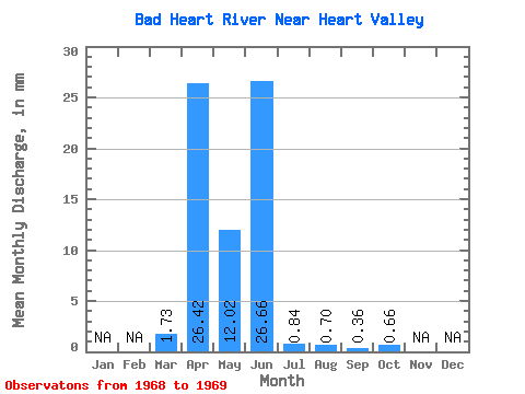
| Statistic | Jan | Feb | Mar | Apr | May | Jun | Jul | Aug | Sep | Oct | Nov | Dec | Annual |
|---|---|---|---|---|---|---|---|---|---|---|---|---|---|
| Mean | 1.73 | 26.42 | 12.03 | 26.66 | 0.84 | 0.70 | 0.36 | 0.66 | |||||
| Standard Deviation | 2.45 | 30.60 | 5.47 | 36.57 | 0.02 | ||||||||
| Min | 0.00 | 4.78 | 8.16 | 0.80 | 0.82 | 0.70 | 0.36 | 0.66 | |||||
| Max | 3.46 | 48.06 | 15.90 | 52.52 | 0.85 | 0.70 | 0.36 | 0.66 | |||||
| Coefficient of Variation | 1.41 | 1.16 | 0.46 | 1.37 | 0.02 |
 Return to R-Arctic Net Home Page