|
|
|||||||||||||||||
| Point ID: 7734 | Downloads | Plots | Site Data | Code: Mo007 |
|
|
|||||||||||||||||
| Download | |
|---|---|
| Site Descriptor Information | Site Time Series Data |
| Link to all available data | |
| View: | Time Series | All |
| Units: | m3/s |
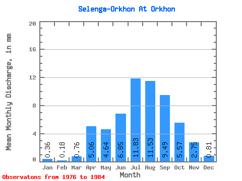
| Statistic | Jan | Feb | Mar | Apr | May | Jun | Jul | Aug | Sep | Oct | Nov | Dec | Annual |
|---|---|---|---|---|---|---|---|---|---|---|---|---|---|
| Mean | 0.36 | 0.18 | 0.76 | 5.06 | 4.64 | 6.85 | 11.83 | 11.53 | 9.49 | 5.57 | 2.75 | 0.81 | 59.56 |
| Standard Deviation | 0.29 | 0.10 | 0.54 | 4.12 | 1.68 | 6.05 | 10.11 | 6.56 | 5.94 | 2.49 | 1.46 | 0.53 | 32.91 |
| Min | 0.10 | 0.04 | 0.24 | 1.87 | 2.61 | 2.75 | 2.04 | 2.67 | 3.41 | 2.84 | 1.37 | 0.39 | 23.01 |
| Max | 1.01 | 0.28 | 1.70 | 14.17 | 8.23 | 22.19 | 34.50 | 23.15 | 21.31 | 10.84 | 5.60 | 2.04 | 129.45 |
| Coefficient of Variation | 0.79 | 0.54 | 0.71 | 0.81 | 0.36 | 0.88 | 0.85 | 0.57 | 0.63 | 0.45 | 0.53 | 0.65 | 0.55 |
 Return to R-Arctic Net Home Page