|
|
|||||||||||||||||
| Point ID: 7730 | Downloads | Plots | Site Data | Code: NO018 |
|
|
|||||||||||||||||
| Download | |
|---|---|
| Site Descriptor Information | Site Time Series Data |
| Link to all available data | |
| View: | Time Series | All |
| Units: | m3/s |
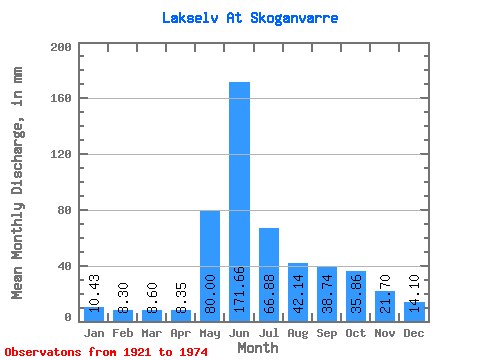
| Statistic | Jan | Feb | Mar | Apr | May | Jun | Jul | Aug | Sep | Oct | Nov | Dec | Annual |
|---|---|---|---|---|---|---|---|---|---|---|---|---|---|
| Mean | 10.43 | 8.37 | 8.60 | 8.35 | 79.99 | 171.66 | 66.87 | 42.13 | 38.74 | 35.85 | 21.70 | 14.10 | 505.55 |
| Standard Deviation | 4.32 | 4.54 | 5.13 | 4.85 | 51.51 | 67.14 | 43.15 | 23.63 | 19.23 | 11.50 | 8.70 | 4.80 | 122.62 |
| Min | 0.90 | 1.91 | 1.84 | 1.98 | 8.75 | 21.66 | 14.41 | 3.27 | 11.18 | 15.61 | 5.56 | 4.58 | 231.11 |
| Max | 21.30 | 21.24 | 20.42 | 20.89 | 194.55 | 380.84 | 255.55 | 114.47 | 117.35 | 67.42 | 44.81 | 23.83 | 929.52 |
| Coefficient of Variation | 0.41 | 0.54 | 0.60 | 0.58 | 0.64 | 0.39 | 0.65 | 0.56 | 0.50 | 0.32 | 0.40 | 0.34 | 0.24 |
 Return to R-Arctic Net Home Page