|
|
|||||||||||||||||
| Point ID: 7728 | Downloads | Plots | Site Data | Code: NO012 |
|
|
|||||||||||||||||
| Download | |
|---|---|
| Site Descriptor Information | Site Time Series Data |
| Link to all available data | |
| View: | Time Series | All |
| Units: | m3/s |
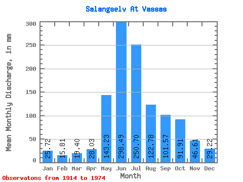
| Statistic | Jan | Feb | Mar | Apr | May | Jun | Jul | Aug | Sep | Oct | Nov | Dec | Annual |
|---|---|---|---|---|---|---|---|---|---|---|---|---|---|
| Mean | 25.71 | 15.95 | 19.39 | 28.04 | 143.21 | 298.49 | 250.66 | 122.76 | 101.57 | 91.90 | 46.61 | 29.21 | 1169.47 |
| Standard Deviation | 25.41 | 10.59 | 14.00 | 18.43 | 66.14 | 84.83 | 78.87 | 41.20 | 37.90 | 52.17 | 31.59 | 20.11 | 196.06 |
| Min | 4.57 | 4.04 | 3.79 | 4.02 | 47.51 | 155.56 | 129.01 | 57.25 | 41.11 | 24.01 | 4.92 | 1.85 | 758.53 |
| Max | 168.39 | 56.29 | 75.54 | 89.38 | 413.80 | 542.89 | 462.14 | 250.25 | 205.13 | 248.69 | 134.07 | 108.18 | 1641.03 |
| Coefficient of Variation | 0.99 | 0.66 | 0.72 | 0.66 | 0.46 | 0.28 | 0.32 | 0.34 | 0.37 | 0.57 | 0.68 | 0.69 | 0.17 |
 Return to R-Arctic Net Home Page