|
|
|||||||||||||||||
| Point ID: 7727 | Downloads | Plots | Site Data | Code: NO011 |
|
|
|||||||||||||||||
| Download | |
|---|---|
| Site Descriptor Information | Site Time Series Data |
| Link to all available data | |
| View: | Time Series | All |
| Units: | m3/s |
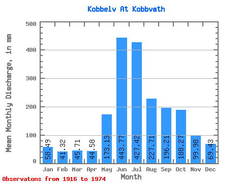
| Statistic | Jan | Feb | Mar | Apr | May | Jun | Jul | Aug | Sep | Oct | Nov | Dec | Annual |
|---|---|---|---|---|---|---|---|---|---|---|---|---|---|
| Mean | 58.48 | 41.67 | 45.70 | 44.59 | 173.10 | 443.77 | 427.36 | 227.68 | 196.21 | 188.24 | 99.97 | 69.41 | 2010.14 |
| Standard Deviation | 48.57 | 33.85 | 34.52 | 22.02 | 77.18 | 110.28 | 127.14 | 77.57 | 77.00 | 97.96 | 64.99 | 50.00 | 377.93 |
| Min | 6.39 | 4.94 | 7.55 | 3.66 | 6.87 | 175.79 | 180.66 | 106.43 | 77.30 | 41.75 | 22.60 | 12.98 | 1141.62 |
| Max | 265.60 | 198.27 | 168.37 | 106.54 | 428.20 | 798.80 | 680.21 | 423.67 | 412.13 | 484.44 | 301.47 | 270.41 | 3041.22 |
| Coefficient of Variation | 0.83 | 0.81 | 0.76 | 0.49 | 0.45 | 0.25 | 0.30 | 0.34 | 0.39 | 0.52 | 0.65 | 0.72 | 0.19 |
 Return to R-Arctic Net Home Page