|
|
|||||||||||||||||
| Point ID: 7704 | Downloads | Plots | Site Data | Code: 15518000 |
|
|
|||||||||||||||||
| Download | |
|---|---|
| Site Descriptor Information | Site Time Series Data |
| Link to all available data | |
| View: | Time Series | All |
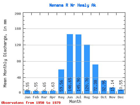
| Units: | m3/s |
| Statistic | Jan | Feb | Mar | Apr | May | Jun | Jul | Aug | Sep | Oct | Nov | Dec | Annual |
|---|---|---|---|---|---|---|---|---|---|---|---|---|---|
| Mean | 8.55 | 6.60 | 6.65 | 7.63 | 59.55 | 146.65 | 145.88 | 120.68 | 72.39 | 32.95 | 15.14 | 10.55 | 632.58 |
| Standard Deviation | 1.83 | 1.30 | 1.31 | 1.55 | 18.26 | 39.87 | 32.69 | 30.45 | 21.72 | 8.79 | 4.83 | 2.88 | 102.61 |
| Min | 3.50 | 2.65 | 2.91 | 3.00 | 14.09 | 81.31 | 90.00 | 66.02 | 31.29 | 15.85 | 5.99 | 4.02 | 409.74 |
| Max | 11.82 | 8.73 | 9.18 | 11.96 | 98.75 | 223.45 | 235.15 | 200.66 | 125.54 | 53.82 | 26.19 | 21.26 | 819.76 |
| Coefficient of Variation | 0.21 | 0.20 | 0.20 | 0.20 | 0.31 | 0.27 | 0.22 | 0.25 | 0.30 | 0.27 | 0.32 | 0.27 | 0.16 |
 Return to R-Arctic Net Home Page