|
|
|||||||||||||||||
| Point ID: 770 | Downloads | Plots | Site Data | Code: 07GH004 |
|
|
|||||||||||||||||
| Download | |
|---|---|
| Site Descriptor Information | Site Time Series Data |
| Link to all available data | |
| View: | Time Series | All |
| Units: | m3/s |
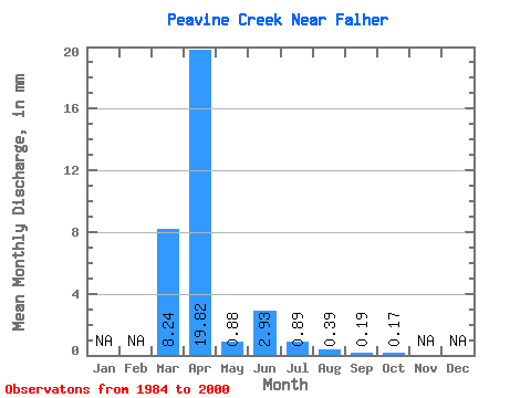
| Statistic | Jan | Feb | Mar | Apr | May | Jun | Jul | Aug | Sep | Oct | Nov | Dec | Annual |
|---|---|---|---|---|---|---|---|---|---|---|---|---|---|
| Mean | 4.91 | 11.81 | 0.52 | 1.75 | 0.53 | 0.24 | 0.11 | 0.10 | |||||
| Standard Deviation | 8.44 | 16.00 | 0.81 | 4.06 | 0.94 | 0.66 | 0.42 | 0.21 | |||||
| Min | 0.00 | 0.06 | 0.01 | 0.00 | 0.00 | 0.00 | 0.00 | 0.00 | |||||
| Max | 29.27 | 58.89 | 2.76 | 15.73 | 2.72 | 2.21 | 1.74 | 0.70 | |||||
| Coefficient of Variation | 1.72 | 1.35 | 1.55 | 2.32 | 1.78 | 2.78 | 3.84 | 2.09 |
 Return to R-Arctic Net Home Page