|
|
|||||||||||||||||
| Point ID: 7691 | Downloads | Plots | Site Data | Code: 15910000 |
|
|
|||||||||||||||||
| Download | |
|---|---|
| Site Descriptor Information | Site Time Series Data |
| Link to all available data | |
| View: | Time Series | All |
| Units: | m3/s |
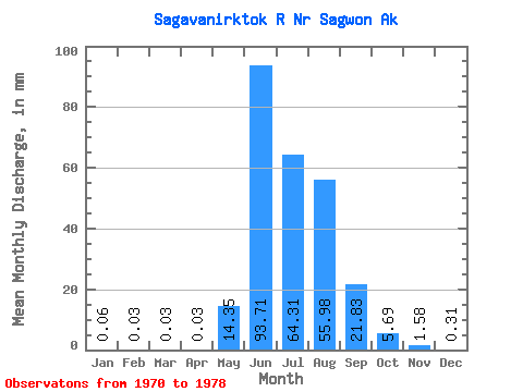
| Statistic | Jan | Feb | Mar | Apr | May | Jun | Jul | Aug | Sep | Oct | Nov | Dec | Annual |
|---|---|---|---|---|---|---|---|---|---|---|---|---|---|
| Mean | 0.06 | 0.03 | 0.03 | 0.03 | 14.35 | 93.71 | 64.30 | 55.97 | 21.83 | 5.69 | 1.58 | 0.31 | 260.42 |
| Standard Deviation | 0.06 | 0.04 | 0.04 | 0.04 | 13.47 | 20.49 | 16.84 | 23.97 | 6.11 | 1.81 | 1.18 | 0.29 | 41.86 |
| Min | 0.02 | 0.00 | 0.00 | 0.00 | 2.46 | 62.99 | 41.14 | 34.26 | 10.16 | 3.25 | 0.43 | 0.06 | 221.99 |
| Max | 0.20 | 0.12 | 0.13 | 0.13 | 39.28 | 120.24 | 94.81 | 89.20 | 29.62 | 9.14 | 3.57 | 0.78 | 332.50 |
| Coefficient of Variation | 1.08 | 1.45 | 1.51 | 1.32 | 0.94 | 0.22 | 0.26 | 0.43 | 0.28 | 0.32 | 0.74 | 0.94 | 0.16 |
 Return to R-Arctic Net Home Page