|
|
|||||||||||||||||
| Point ID: 7655 | Downloads | Plots | Site Data | Code: 71243 |
|
|
|||||||||||||||||
| Download | |
|---|---|
| Site Descriptor Information | Site Time Series Data |
| Link to all available data | |
| View: | Time Series | All |
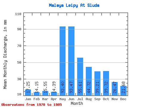
| Units: | m3/s |
| Statistic | Jan | Feb | Mar | Apr | May | Jun | Jul | Aug | Sep | Oct | Nov | Dec | Annual |
|---|---|---|---|---|---|---|---|---|---|---|---|---|---|
| Mean | 17.21 | 14.30 | 15.51 | 14.41 | 93.37 | 93.51 | 55.60 | 44.74 | 39.23 | 39.72 | 26.50 | 21.70 | 486.38 |
| Standard Deviation | 4.51 | 3.95 | 2.65 | 3.85 | 38.31 | 35.11 | 25.56 | 15.19 | 12.97 | 8.59 | 4.96 | 4.94 | 84.58 |
| Min | 13.62 | 11.37 | 12.48 | 9.55 | 26.10 | 46.13 | 26.10 | 27.23 | 25.26 | 29.50 | 19.77 | 15.89 | 334.32 |
| Max | 24.96 | 20.68 | 19.29 | 19.77 | 127.09 | 140.58 | 90.78 | 65.81 | 64.80 | 53.33 | 34.05 | 30.64 | 552.41 |
| Coefficient of Variation | 0.26 | 0.28 | 0.17 | 0.27 | 0.41 | 0.38 | 0.46 | 0.34 | 0.33 | 0.22 | 0.19 | 0.23 | 0.17 |
 Return to R-Arctic Net Home Page