|
|
|||||||||||||||||
| Point ID: 7641 | Downloads | Plots | Site Data | Code: 71192 |
|
|
|||||||||||||||||
| Download | |
|---|---|
| Site Descriptor Information | Site Time Series Data |
| Link to all available data | |
| View: | Time Series | All |
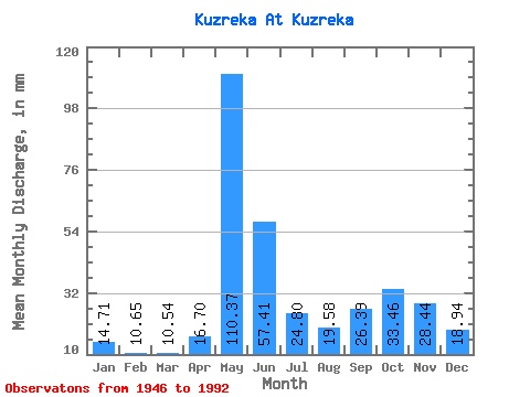
| Units: | m3/s |
| Statistic | Jan | Feb | Mar | Apr | May | Jun | Jul | Aug | Sep | Oct | Nov | Dec | Annual |
|---|---|---|---|---|---|---|---|---|---|---|---|---|---|
| Mean | 14.70 | 10.74 | 10.54 | 16.70 | 110.36 | 57.41 | 24.80 | 19.58 | 26.39 | 33.45 | 28.44 | 18.94 | 372.18 |
| Standard Deviation | 5.28 | 3.63 | 3.00 | 9.74 | 37.51 | 31.08 | 13.00 | 11.15 | 12.29 | 14.75 | 16.65 | 9.45 | 79.63 |
| Min | 7.07 | 4.39 | 4.50 | 4.67 | 46.38 | 15.45 | 9.11 | 5.25 | 6.22 | 6.96 | 5.29 | 6.53 | 184.52 |
| Max | 31.17 | 24.01 | 19.71 | 47.48 | 207.81 | 161.74 | 58.17 | 58.70 | 46.97 | 64.49 | 70.71 | 61.27 | 578.71 |
| Coefficient of Variation | 0.36 | 0.34 | 0.28 | 0.58 | 0.34 | 0.54 | 0.52 | 0.57 | 0.47 | 0.44 | 0.59 | 0.50 | 0.21 |
 Return to R-Arctic Net Home Page