|
|
|||||||||||||||||
| Point ID: 7638 | Downloads | Plots | Site Data | Code: 71185 |
|
|
|||||||||||||||||
| Download | |
|---|---|
| Site Descriptor Information | Site Time Series Data |
| Link to all available data | |
| View: | Time Series | All |
| Units: | m3/s |
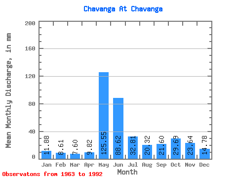
| Statistic | Jan | Feb | Mar | Apr | May | Jun | Jul | Aug | Sep | Oct | Nov | Dec | Annual |
|---|---|---|---|---|---|---|---|---|---|---|---|---|---|
| Mean | 11.88 | 8.68 | 7.60 | 9.82 | 125.53 | 88.62 | 32.80 | 20.31 | 21.60 | 29.68 | 23.64 | 14.78 | 403.46 |
| Standard Deviation | 4.54 | 3.31 | 2.69 | 6.51 | 49.13 | 50.36 | 12.66 | 9.95 | 10.07 | 13.96 | 13.16 | 6.11 | 67.54 |
| Min | 3.88 | 3.27 | 2.79 | 4.33 | 24.51 | 36.90 | 16.79 | 8.26 | 6.96 | 8.40 | 4.90 | 3.95 | 271.36 |
| Max | 21.65 | 14.91 | 12.96 | 29.65 | 208.34 | 265.79 | 68.54 | 49.02 | 47.89 | 61.96 | 58.43 | 28.37 | 497.20 |
| Coefficient of Variation | 0.38 | 0.38 | 0.35 | 0.66 | 0.39 | 0.57 | 0.39 | 0.49 | 0.47 | 0.47 | 0.56 | 0.41 | 0.17 |
 Return to R-Arctic Net Home Page