|
|
|||||||||||||||||
| Point ID: 7635 | Downloads | Plots | Site Data | Code: 71179 |
|
|
|||||||||||||||||
| Download | |
|---|---|
| Site Descriptor Information | Site Time Series Data |
| Link to all available data | |
| View: | Time Series | All |
| Units: | m3/s |
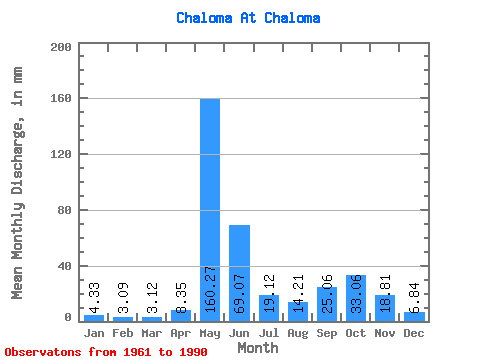
| Statistic | Jan | Feb | Mar | Apr | May | Jun | Jul | Aug | Sep | Oct | Nov | Dec | Annual |
|---|---|---|---|---|---|---|---|---|---|---|---|---|---|
| Mean | 4.33 | 3.11 | 3.12 | 8.35 | 160.25 | 69.07 | 19.12 | 14.20 | 25.06 | 33.06 | 18.82 | 6.84 | 363.14 |
| Standard Deviation | 0.92 | 0.75 | 0.88 | 13.50 | 57.98 | 58.14 | 12.29 | 9.76 | 12.64 | 18.80 | 13.38 | 2.86 | 73.57 |
| Min | 2.92 | 1.37 | 1.22 | 1.24 | 28.25 | 10.65 | 5.36 | 4.30 | 4.97 | 7.12 | 4.49 | 2.95 | 250.07 |
| Max | 5.87 | 5.06 | 5.70 | 69.67 | 277.63 | 233.28 | 48.65 | 36.12 | 49.70 | 75.92 | 52.79 | 14.89 | 546.38 |
| Coefficient of Variation | 0.21 | 0.24 | 0.28 | 1.62 | 0.36 | 0.84 | 0.64 | 0.69 | 0.51 | 0.57 | 0.71 | 0.42 | 0.20 |
 Return to R-Arctic Net Home Page