|
|
|||||||||||||||||
| Point ID: 7630 | Downloads | Plots | Site Data | Code: 71169 |
|
|
|||||||||||||||||
| Download | |
|---|---|
| Site Descriptor Information | Site Time Series Data |
| Link to all available data | |
| View: | Time Series | All |
| Units: | m3/s |
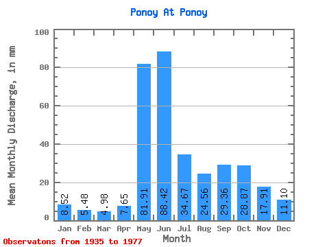
| Statistic | Jan | Feb | Mar | Apr | May | Jun | Jul | Aug | Sep | Oct | Nov | Dec | Annual |
|---|---|---|---|---|---|---|---|---|---|---|---|---|---|
| Mean | 8.52 | 5.53 | 4.98 | 7.65 | 81.90 | 88.42 | 34.66 | 24.55 | 29.36 | 28.86 | 17.91 | 11.10 | 346.42 |
| Standard Deviation | 4.22 | 3.43 | 3.14 | 6.73 | 53.16 | 41.52 | 13.49 | 10.82 | 11.37 | 11.28 | 9.16 | 3.57 | 74.91 |
| Min | 4.04 | 2.79 | 2.82 | 2.54 | 6.85 | 14.00 | 6.06 | 4.28 | 5.07 | 7.08 | 4.95 | 3.77 | 170.45 |
| Max | 31.18 | 24.40 | 22.55 | 28.48 | 225.52 | 180.76 | 70.65 | 53.91 | 49.62 | 56.03 | 46.21 | 20.44 | 579.79 |
| Coefficient of Variation | 0.49 | 0.62 | 0.63 | 0.88 | 0.65 | 0.47 | 0.39 | 0.44 | 0.39 | 0.39 | 0.51 | 0.32 | 0.22 |
 Return to R-Arctic Net Home Page