|
|
|||||||||||||||||
| Point ID: 7628 | Downloads | Plots | Site Data | Code: 71165 |
|
|
|||||||||||||||||
| Download | |
|---|---|
| Site Descriptor Information | Site Time Series Data |
| Link to all available data | |
| View: | Time Series | All |
| Units: | m3/s |
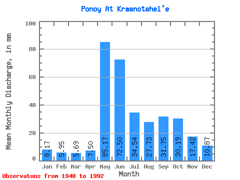
| Statistic | Jan | Feb | Mar | Apr | May | Jun | Jul | Aug | Sep | Oct | Nov | Dec | Annual |
|---|---|---|---|---|---|---|---|---|---|---|---|---|---|
| Mean | 8.17 | 6.00 | 5.69 | 7.50 | 85.16 | 72.50 | 34.54 | 27.72 | 31.75 | 30.19 | 17.41 | 10.87 | 337.45 |
| Standard Deviation | 1.98 | 1.27 | 1.14 | 6.62 | 40.87 | 31.62 | 12.07 | 11.66 | 12.55 | 12.57 | 8.54 | 3.06 | 69.25 |
| Min | 4.10 | 3.32 | 3.22 | 3.52 | 6.56 | 23.81 | 12.72 | 11.46 | 10.82 | 10.26 | 5.62 | 4.71 | 148.25 |
| Max | 13.00 | 8.58 | 8.01 | 37.83 | 165.88 | 153.75 | 66.84 | 64.74 | 55.51 | 64.88 | 45.31 | 17.29 | 517.38 |
| Coefficient of Variation | 0.24 | 0.21 | 0.20 | 0.88 | 0.48 | 0.44 | 0.35 | 0.42 | 0.40 | 0.42 | 0.49 | 0.28 | 0.20 |
 Return to R-Arctic Net Home Page