|
|
|||||||||||||||||
| Point ID: 7624 | Downloads | Plots | Site Data | Code: 71160 |
|
|
|||||||||||||||||
| Download | |
|---|---|
| Site Descriptor Information | Site Time Series Data |
| Link to all available data | |
| View: | Time Series | All |
| Units: | m3/s |
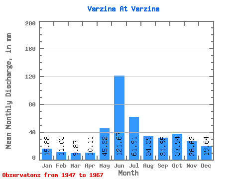
| Statistic | Jan | Feb | Mar | Apr | May | Jun | Jul | Aug | Sep | Oct | Nov | Dec | Annual |
|---|---|---|---|---|---|---|---|---|---|---|---|---|---|
| Mean | 15.87 | 11.13 | 9.87 | 10.11 | 45.31 | 121.67 | 61.90 | 34.39 | 31.95 | 37.94 | 26.62 | 19.63 | 425.83 |
| Standard Deviation | 4.78 | 2.44 | 2.19 | 2.32 | 31.63 | 33.84 | 25.57 | 15.38 | 11.52 | 17.47 | 8.31 | 5.77 | 81.85 |
| Min | 8.76 | 7.04 | 5.93 | 5.25 | 9.27 | 45.84 | 19.06 | 9.83 | 13.67 | 12.42 | 10.45 | 8.68 | 232.20 |
| Max | 25.89 | 15.63 | 13.04 | 14.61 | 127.04 | 179.30 | 137.00 | 65.51 | 54.84 | 77.91 | 40.06 | 32.09 | 547.04 |
| Coefficient of Variation | 0.30 | 0.22 | 0.22 | 0.23 | 0.70 | 0.28 | 0.41 | 0.45 | 0.36 | 0.46 | 0.31 | 0.29 | 0.19 |
 Return to R-Arctic Net Home Page