|
|
|||||||||||||||||
| Point ID: 7622 | Downloads | Plots | Site Data | Code: 71158 |
|
|
|||||||||||||||||
| Download | |
|---|---|
| Site Descriptor Information | Site Time Series Data |
| Link to all available data | |
| View: | Time Series | All |
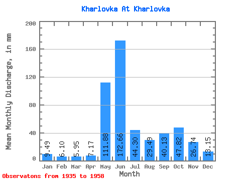
| Units: | m3/s |
| Statistic | Jan | Feb | Mar | Apr | May | Jun | Jul | Aug | Sep | Oct | Nov | Dec | Annual |
|---|---|---|---|---|---|---|---|---|---|---|---|---|---|
| Mean | 9.49 | 6.16 | 5.95 | 7.17 | 111.86 | 172.66 | 44.30 | 29.48 | 40.13 | 47.82 | 26.74 | 13.15 | 515.56 |
| Standard Deviation | 3.52 | 2.14 | 2.02 | 3.87 | 66.56 | 75.92 | 22.73 | 13.73 | 16.59 | 20.75 | 14.02 | 5.56 | 104.94 |
| Min | 4.05 | 3.69 | 2.91 | 3.53 | 14.00 | 47.28 | 16.69 | 6.89 | 10.16 | 15.07 | 10.36 | 4.35 | 278.13 |
| Max | 17.36 | 11.32 | 11.20 | 22.14 | 238.19 | 308.69 | 94.61 | 60.15 | 78.54 | 90.57 | 65.00 | 28.39 | 725.03 |
| Coefficient of Variation | 0.37 | 0.35 | 0.34 | 0.54 | 0.59 | 0.44 | 0.51 | 0.47 | 0.41 | 0.43 | 0.52 | 0.42 | 0.20 |
 Return to R-Arctic Net Home Page