|
|
|||||||||||||||||
| Point ID: 762 | Downloads | Plots | Site Data | Code: 07GF006 |
|
|
|||||||||||||||||
| Download | |
|---|---|
| Site Descriptor Information | Site Time Series Data |
| Link to all available data | |
| View: | Time Series | All |
| Units: | m3/s |
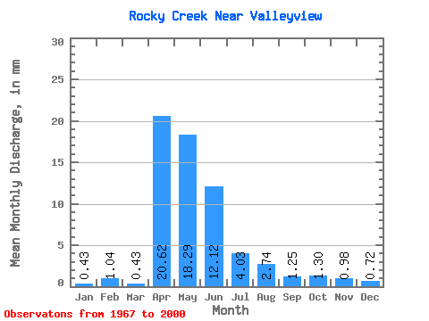
| Statistic | Jan | Feb | Mar | Apr | May | Jun | Jul | Aug | Sep | Oct | Nov | Dec | Annual |
|---|---|---|---|---|---|---|---|---|---|---|---|---|---|
| Mean | 0.50 | 1.05 | 0.45 | 20.60 | 18.35 | 12.09 | 4.09 | 2.71 | 1.30 | 1.22 | 1.04 | 0.67 | |
| Standard Deviation | 0.30 | 0.40 | 17.93 | 25.10 | 15.53 | 6.60 | 8.01 | 1.94 | 1.79 | 0.49 | 0.08 | ||
| Min | 0.29 | 1.05 | 0.00 | 0.70 | 0.43 | 0.28 | 0.14 | 0.00 | 0.00 | 0.00 | 0.70 | 0.58 | |
| Max | 0.72 | 1.05 | 1.30 | 63.41 | 120.80 | 55.46 | 25.63 | 40.46 | 8.92 | 7.78 | 1.39 | 0.72 | |
| Coefficient of Variation | 0.61 | 0.90 | 0.87 | 1.37 | 1.28 | 1.61 | 2.96 | 1.49 | 1.47 | 0.47 | 0.12 |
 Return to R-Arctic Net Home Page