|
|
|||||||||||||||||
| Point ID: 7607 | Downloads | Plots | Site Data | Code: 71130 |
|
|
|||||||||||||||||
| Download | |
|---|---|
| Site Descriptor Information | Site Time Series Data |
| Link to all available data | |
| View: | Time Series | All |
| Units: | m3/s |
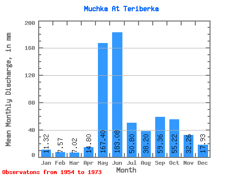
| Statistic | Jan | Feb | Mar | Apr | May | Jun | Jul | Aug | Sep | Oct | Nov | Dec | Annual |
|---|---|---|---|---|---|---|---|---|---|---|---|---|---|
| Mean | 11.32 | 7.63 | 7.02 | 14.80 | 167.38 | 183.08 | 50.80 | 38.20 | 59.35 | 55.21 | 32.26 | 17.93 | 657.18 |
| Standard Deviation | 2.83 | 1.81 | 1.82 | 20.72 | 89.42 | 119.03 | 23.15 | 21.80 | 37.67 | 21.92 | 9.82 | 6.07 | 124.37 |
| Min | 6.25 | 4.34 | 4.46 | 4.32 | 15.03 | 35.42 | 9.07 | 7.44 | 22.46 | 22.76 | 17.57 | 9.82 | 363.09 |
| Max | 15.18 | 10.71 | 10.71 | 72.58 | 330.29 | 447.84 | 101.47 | 81.53 | 155.52 | 89.56 | 48.38 | 29.16 | 809.02 |
| Coefficient of Variation | 0.25 | 0.24 | 0.26 | 1.40 | 0.53 | 0.65 | 0.46 | 0.57 | 0.64 | 0.40 | 0.30 | 0.34 | 0.19 |
 Return to R-Arctic Net Home Page