|
|
|||||||||||||||||
| Point ID: 7606 | Downloads | Plots | Site Data | Code: 71128 |
|
|
|||||||||||||||||
| Download | |
|---|---|
| Site Descriptor Information | Site Time Series Data |
| Link to all available data | |
| View: | Time Series | All |
| Units: | m3/s |
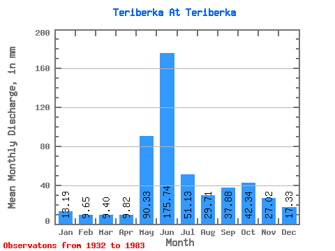
| Statistic | Jan | Feb | Mar | Apr | May | Jun | Jul | Aug | Sep | Oct | Nov | Dec | Annual |
|---|---|---|---|---|---|---|---|---|---|---|---|---|---|
| Mean | 13.18 | 9.73 | 9.40 | 9.82 | 90.32 | 175.74 | 51.13 | 29.71 | 37.88 | 42.33 | 27.02 | 17.33 | 510.38 |
| Standard Deviation | 4.16 | 2.75 | 2.11 | 4.28 | 65.93 | 71.76 | 25.78 | 13.39 | 16.35 | 15.73 | 9.71 | 5.04 | 96.89 |
| Min | 6.04 | 2.88 | 4.52 | 4.09 | 9.32 | 34.65 | 10.57 | 5.04 | 13.86 | 17.50 | 9.19 | 9.37 | 256.10 |
| Max | 25.72 | 14.25 | 13.65 | 31.82 | 275.75 | 319.51 | 121.97 | 59.26 | 104.96 | 86.84 | 57.87 | 28.90 | 700.97 |
| Coefficient of Variation | 0.32 | 0.28 | 0.23 | 0.44 | 0.73 | 0.41 | 0.50 | 0.45 | 0.43 | 0.37 | 0.36 | 0.29 | 0.19 |
 Return to R-Arctic Net Home Page