|
|
|||||||||||||||||
| Point ID: 7599 | Downloads | Plots | Site Data | Code: 71098 |
|
|
|||||||||||||||||
| Download | |
|---|---|
| Site Descriptor Information | Site Time Series Data |
| Link to all available data | |
| View: | Time Series | All |
| Units: | m3/s |
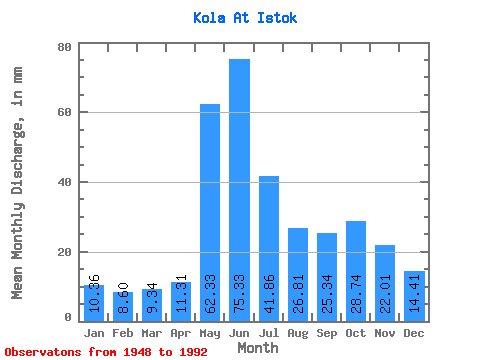
| Statistic | Jan | Feb | Mar | Apr | May | Jun | Jul | Aug | Sep | Oct | Nov | Dec | Annual |
|---|---|---|---|---|---|---|---|---|---|---|---|---|---|
| Mean | 10.36 | 8.67 | 9.34 | 11.31 | 62.33 | 75.33 | 41.85 | 26.80 | 25.34 | 28.74 | 22.01 | 14.41 | 342.18 |
| Standard Deviation | 4.20 | 3.46 | 3.38 | 3.88 | 27.52 | 21.86 | 18.22 | 13.48 | 13.64 | 12.08 | 8.44 | 6.45 | 73.32 |
| Min | 0.21 | 0.26 | 0.01 | 4.73 | 18.35 | 34.53 | 16.44 | 6.80 | 6.36 | 6.24 | 4.15 | 1.63 | 222.38 |
| Max | 17.93 | 16.63 | 17.14 | 22.45 | 136.46 | 119.01 | 102.93 | 68.00 | 79.79 | 54.03 | 45.98 | 30.65 | 559.48 |
| Coefficient of Variation | 0.41 | 0.40 | 0.36 | 0.34 | 0.44 | 0.29 | 0.43 | 0.50 | 0.54 | 0.42 | 0.38 | 0.45 | 0.21 |
 Return to R-Arctic Net Home Page