|
|
|||||||||||||||||
| Point ID: 7581 | Downloads | Plots | Site Data | Code: 71048 |
|
|
|||||||||||||||||
| Download | |
|---|---|
| Site Descriptor Information | Site Time Series Data |
| Link to all available data | |
| View: | Time Series | All |
| Units: | m3/s |
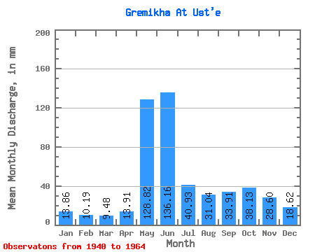
| Statistic | Jan | Feb | Mar | Apr | May | Jun | Jul | Aug | Sep | Oct | Nov | Dec | Annual |
|---|---|---|---|---|---|---|---|---|---|---|---|---|---|
| Mean | 13.86 | 10.29 | 9.48 | 13.90 | 128.78 | 136.16 | 40.93 | 31.03 | 33.91 | 38.12 | 28.60 | 18.62 | 487.63 |
| Standard Deviation | 4.34 | 2.15 | 1.18 | 13.61 | 63.88 | 78.74 | 21.23 | 17.94 | 22.19 | 20.96 | 9.86 | 6.61 | 92.32 |
| Min | 6.93 | 6.89 | 7.56 | 6.71 | 30.88 | 31.41 | 13.55 | 6.93 | 12.81 | 13.55 | 8.84 | 6.93 | 280.95 |
| Max | 21.74 | 12.63 | 11.03 | 55.80 | 237.55 | 261.33 | 84.75 | 66.16 | 92.70 | 85.07 | 41.17 | 29.93 | 614.80 |
| Coefficient of Variation | 0.31 | 0.21 | 0.12 | 0.98 | 0.50 | 0.58 | 0.52 | 0.58 | 0.66 | 0.55 | 0.34 | 0.35 | 0.19 |
 Return to R-Arctic Net Home Page