|
|
|||||||||||||||||
| Point ID: 7567 | Downloads | Plots | Site Data | Code: 70844 |
|
|
|||||||||||||||||
| Download | |
|---|---|
| Site Descriptor Information | Site Time Series Data |
| Link to all available data | |
| View: | Time Series | All |
| Units: | m3/s |
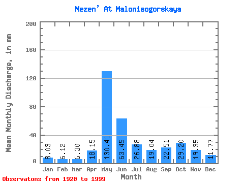
| Statistic | Jan | Feb | Mar | Apr | May | Jun | Jul | Aug | Sep | Oct | Nov | Dec | Annual |
|---|---|---|---|---|---|---|---|---|---|---|---|---|---|
| Mean | 8.03 | 6.17 | 6.30 | 18.15 | 130.40 | 63.45 | 26.87 | 19.04 | 22.51 | 29.19 | 19.35 | 11.77 | 359.07 |
| Standard Deviation | 2.03 | 1.37 | 1.15 | 21.08 | 37.31 | 34.04 | 12.09 | 10.87 | 10.96 | 13.17 | 10.10 | 4.02 | 60.02 |
| Min | 4.80 | 3.92 | 4.23 | 4.60 | 45.96 | 20.08 | 8.93 | 6.22 | 6.39 | 7.93 | 6.85 | 5.75 | 195.85 |
| Max | 15.72 | 11.21 | 9.73 | 97.75 | 208.92 | 173.72 | 64.10 | 54.60 | 76.29 | 72.17 | 56.99 | 29.58 | 505.67 |
| Coefficient of Variation | 0.25 | 0.22 | 0.18 | 1.16 | 0.29 | 0.54 | 0.45 | 0.57 | 0.49 | 0.45 | 0.52 | 0.34 | 0.17 |
 Return to R-Arctic Net Home Page