|
|
|||||||||||||||||
| Point ID: 7557 | Downloads | Plots | Site Data | Code: 70596 |
|
|
|||||||||||||||||
| Download | |
|---|---|
| Site Descriptor Information | Site Time Series Data |
| Link to all available data | |
| View: | Time Series | All |
| Units: | m3/s |
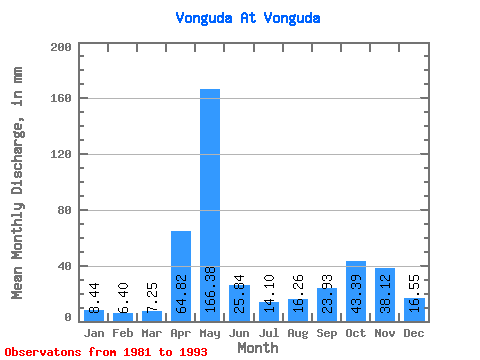
| Statistic | Jan | Feb | Mar | Apr | May | Jun | Jul | Aug | Sep | Oct | Nov | Dec | Annual |
|---|---|---|---|---|---|---|---|---|---|---|---|---|---|
| Mean | 8.45 | 6.46 | 7.26 | 64.82 | 166.36 | 25.84 | 14.10 | 16.25 | 23.93 | 43.39 | 38.12 | 16.55 | 427.32 |
| Standard Deviation | 3.89 | 2.37 | 3.43 | 66.39 | 55.50 | 12.21 | 6.54 | 9.29 | 9.23 | 26.09 | 24.87 | 12.18 | 77.22 |
| Min | 5.25 | 3.29 | 3.14 | 4.35 | 96.67 | 10.74 | 5.88 | 4.25 | 5.51 | 13.53 | 8.25 | 6.46 | 295.69 |
| Max | 16.61 | 10.77 | 14.25 | 191.97 | 262.79 | 45.95 | 31.00 | 33.08 | 42.34 | 108.84 | 79.01 | 41.53 | 592.38 |
| Coefficient of Variation | 0.46 | 0.37 | 0.47 | 1.02 | 0.33 | 0.47 | 0.46 | 0.57 | 0.39 | 0.60 | 0.65 | 0.74 | 0.18 |
 Return to R-Arctic Net Home Page