|
|
|||||||||||||||||
| Point ID: 7525 | Downloads | Plots | Site Data | Code: 70542 |
|
|
|||||||||||||||||
| Download | |
|---|---|
| Site Descriptor Information | Site Time Series Data |
| Link to all available data | |
| View: | Time Series | All |
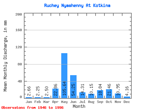
| Units: | m3/s |
| Statistic | Jan | Feb | Mar | Apr | May | Jun | Jul | Aug | Sep | Oct | Nov | Dec | Annual |
|---|---|---|---|---|---|---|---|---|---|---|---|---|---|
| Mean | 2.74 | 2.35 | 2.54 | 22.93 | 105.69 | 54.24 | 14.24 | 10.21 | 18.83 | 21.48 | 10.95 | 4.19 | 268.34 |
| Standard Deviation | 0.98 | 0.80 | 0.92 | 37.65 | 68.87 | 49.91 | 14.16 | 8.62 | 14.15 | 11.99 | 8.93 | 1.80 | 70.98 |
| Min | 0.00 | 0.00 | 0.00 | 0.00 | 3.66 | 6.60 | 2.99 | 2.83 | 2.90 | 2.00 | 3.06 | 1.66 | 113.04 |
| Max | 4.82 | 4.24 | 4.66 | 177.09 | 314.37 | 233.44 | 68.20 | 36.59 | 66.01 | 49.90 | 54.74 | 10.64 | 435.83 |
| Coefficient of Variation | 0.36 | 0.34 | 0.36 | 1.64 | 0.65 | 0.92 | 0.99 | 0.84 | 0.75 | 0.56 | 0.82 | 0.43 | 0.27 |
 Return to R-Arctic Net Home Page