|
|
|||||||||||||||||
| Point ID: 7524 | Downloads | Plots | Site Data | Code: 70540 |
|
|
|||||||||||||||||
| Download | |
|---|---|
| Site Descriptor Information | Site Time Series Data |
| Link to all available data | |
| View: | Time Series | All |
| Units: | m3/s |
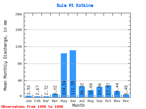
| Statistic | Jan | Feb | Mar | Apr | May | Jun | Jul | Aug | Sep | Oct | Nov | Dec | Annual |
|---|---|---|---|---|---|---|---|---|---|---|---|---|---|
| Mean | 3.93 | 2.69 | 2.72 | 8.02 | 104.53 | 111.55 | 26.32 | 16.66 | 24.86 | 27.97 | 14.44 | 6.48 | 349.93 |
| Standard Deviation | 1.34 | 0.92 | 0.88 | 13.33 | 55.12 | 61.45 | 12.62 | 9.98 | 11.20 | 13.05 | 8.38 | 2.45 | 61.31 |
| Min | 2.15 | 1.36 | 1.04 | 1.13 | 2.51 | 29.70 | 10.65 | 5.73 | 5.92 | 6.11 | 4.18 | 2.38 | 206.26 |
| Max | 8.16 | 5.86 | 5.36 | 70.44 | 226.84 | 285.12 | 71.83 | 47.89 | 53.37 | 69.63 | 47.57 | 12.98 | 514.58 |
| Coefficient of Variation | 0.34 | 0.34 | 0.32 | 1.66 | 0.53 | 0.55 | 0.48 | 0.60 | 0.45 | 0.47 | 0.58 | 0.38 | 0.17 |
 Return to R-Arctic Net Home Page