|
|
|||||||||||||||||
| Point ID: 7520 | Downloads | Plots | Site Data | Code: 70532 |
|
|
|||||||||||||||||
| Download | |
|---|---|
| Site Descriptor Information | Site Time Series Data |
| Link to all available data | |
| View: | Time Series | All |
| Units: | m3/s |
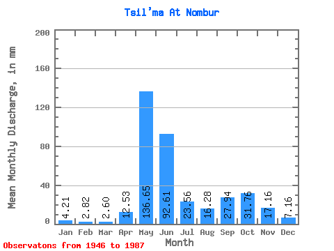
| Statistic | Jan | Feb | Mar | Apr | May | Jun | Jul | Aug | Sep | Oct | Nov | Dec | Annual |
|---|---|---|---|---|---|---|---|---|---|---|---|---|---|
| Mean | 4.21 | 2.85 | 2.59 | 12.53 | 136.63 | 92.61 | 23.56 | 16.27 | 27.94 | 31.75 | 17.16 | 7.16 | 375.44 |
| Standard Deviation | 1.72 | 0.94 | 0.82 | 20.72 | 53.88 | 64.18 | 15.10 | 12.91 | 16.03 | 15.83 | 13.57 | 3.69 | 64.43 |
| Min | 1.81 | 1.28 | 1.01 | 1.44 | 14.76 | 22.18 | 7.53 | 5.00 | 5.70 | 4.49 | 2.31 | 1.01 | 217.76 |
| Max | 9.04 | 5.16 | 4.49 | 91.35 | 236.81 | 268.00 | 74.48 | 53.73 | 65.76 | 64.25 | 82.27 | 15.64 | 491.57 |
| Coefficient of Variation | 0.41 | 0.33 | 0.32 | 1.65 | 0.39 | 0.69 | 0.64 | 0.79 | 0.57 | 0.50 | 0.79 | 0.52 | 0.17 |
 Return to R-Arctic Net Home Page